
Small-scale spatial resolution of the soil phytolith record in a rainforest and a dry forest in Costa Rica
- Post by: Doris Barboni
- May 6, 2019
- Comments off
Crifò, C. and Strömberg, C.A., 2019. Small-scale spatial resolution of the soil phytolith record in a Neotropical rainforest and a dry forest in Costa Rica: applications to the deep-time fossil phytolith record. Palaeogeography, Palaeoclimatology, Palaeoecology. doi: https://doi.org/10.1016/j.palaeo.2019.03.008
Our objective was to define guidelines for the collection of soil samples to conduct phytolith modern analogue studies applicable to pre-Quaternary phytolith assemblages from paleosols. Phytolith analysis is a well-established tool in archaeology and Quaternary paleoecology and has become a source of data for deep-time paleoecological studies in the last 15 years. However, soil phytolith inventories from extant vegetation types, representing modern analogues suffer from several methodological shortcomings limiting inter-study comparisons, and the development of a single, and repeatable protocol for soil sample collection.
We addressed the following questions:
1) Do phytoliths from the lower portion of the A-horizon (more commonly preserved in paleosols) reflect standing vegetation equally well as the upper A-horizon?
2) Is current paleosol sampling methodology (i.e. point soil samples) appropriate to capture standing vegetation cover, or should we combine multiple soil samples within a small area to capture spatial vegetation variability (as it is commonly done in modern analogue studies)?
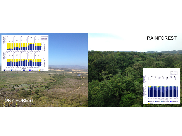
To answer these questions, we compared phytolith assemblages from upper vs. lower soil A-horizons, and composites vs. single phytolith assemblages from 10 × 10 m quadrats in a dry and rainforest in Costa Rica.
Results suggest that the typical approach in deep-time paleoecology of taking point samples from the lower A-horizon of paleosols is valid for the two studied vegetation types (rainforest and dry forest). We further justify this approach because a) the upper portion of the A-horizon is often truncated by erosion in paleosols, and b) point samples are time-averaged, and combining multiple point samples likely amplifies time-averaging rather than providing more accurate reconstructions of the vegetation at a given time.